Community Scale Hazard Resilience, Mitigation and Adaptation
Description: In addition to developing fragility models for specific infrastructure, Padgett Research Group also actively performs research to assess the vulnerability of infrastructure systems at a regional or community scale and understand cascading socio-economic consequences. Our work develops tools to improve large-scale regional risk assessment, evaluate post-hazard accessibility, prioritize mitigation strategies at the regional scale, and evaluate community resilience. Much of this work is performed as a part of multi-disciplinary and multi-institutional collaboration.
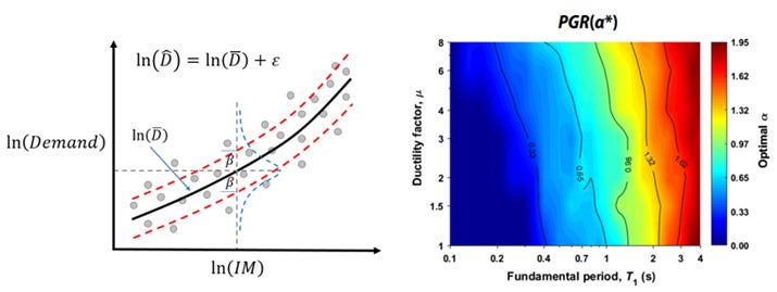
A) Advanced Intensity Measures for Improved Regional Risk Assessment
Description: Ground motion intensity measures (IMs) are metrics quantifying the level of ground excitation of a site under earthquake events. In regional seismic risk assessment, portfolio-level surrogate demand models (SDMs) are statistical models that offer probabilistic descriptions of the structural seismic demand conditioned the seismic hazard input, i.e., the IMs. However, large uncertainties still exist in the SDMs particularly due to the inferior predictive power of the commonly adopted conventional scalar IMs. To facilitate more accurate seismic demand estimation for spatially distributed structural portfolios and lifeline systems, the Padgett Research Group and collaborators (Dr. Shafieezadeh) are developing advanced IMs (e.g., fractional order IMs and posterior IMs) together with implementing advanced statistical and machine learning techniques to better characterize the hazard-demand relationship. Moreover, we are also developing the corresponding probabilistic hazard prediction models to facilitate the hazard computability of the proposed IMs. The implementation of these advanced IMs can lead to more accurate and reliable regional seismic risk estimates.
Figure:
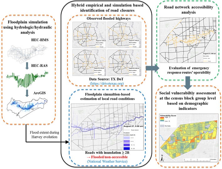
B) Revealing and Promoting Post-Hazard Accessibility in Flood and Surge Events
Description: Urban flooding and coastal surge events have the potential to hamper the functionality of road transportation networks. In the short term, overtopped/damaged bridges and inundated roadways render key routes impassable. In the long term, potential damage, washout, and debris can extend the impacts on communities. Ongoing research by the Padgett Research Group and collaborators (SSPEED Center and Kinder Institute for Urban Research) seek to address the challenges of mobility and accessibility during storm events and their effects on community resilience considering sociodemographic factors. Currently, a particular focus of this research is to develop methods to reveal the immediate and time-evolving impacts of flooding on transportation mobility around a city including access to critical facilities like hospitals and fire stations. This work also aims to develop practical tools to improve situational awareness with near real-time predictions of flood impacts, route safety, travel time, and temporal evolution of transportation accessibility during a flood/surge event.
Figure:
C) Hybrid Metrics of Coastal Resilience
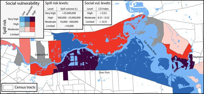
Description: In parallel to our work on post-hazard accessibility of coastal communities and regional risk assessments, Padgett Research Group also develops and proposes new hybrid metrics to further improve the assessment of the resilience of coastal communities. Much of this work leverages collaboration with our partners via the SSPEED Center and Kinder Institute for Urban Research at Rice University (and Dr. Elliot from Sociology), and from the NIST-funded Center of Excellence for Risk-Based Community Resilience Planning. With respect to post-hazard accessibility, work has focused on metrics related to accessibility of at-risk nonevacues, considering physical infrastructure vulnerability (transporation and housing) along with social vulnerability and demographic composition. With petrochemical infrastructure, spill risk assessment were coupled with the social vulnerability assessment of communities living near these ASTs to develop bivariate maps as shown below. Such bivariate maps can help to identify the most vulnerable communities not only due to their higher exposure to spill risks from storms, but because of the intersection between such an higher exposure and lower capacity of communities to prepare, respond, and recover from potential spills.
Figures:
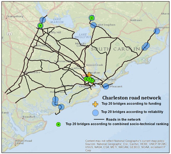
D) Prioritizing Upgrade Investment with Socio-Technical Considerations
Description: Past and ongoing work in the Padgett Research Group explores resource allocation and prioritization of upgrade to infrastructure systems across a region given exposure to various threats, such as deterioration or natural hazards. For example, combining topological or regional importance with bridge reliability information can provide a ranking system to prioritize bridge upgrades to minimize loss of accessibility to the community after an earthquake. However, in reality, most upgrade decisions in practice are governed by the availability of infrastructure funding for the region, influenced not only by need but also other political drivers. In collaboration with experts in network reliability (Dr. Dueas-Osorio’s group) and political science (Dr. Stein’s group) ongoing research develops and explores methods for “socio-technical ranking” where funding allocation patterns also inform the prioritization process. In other work, new component importance measures are explored in which system failure events are defined on the basis of risk-based sustainability indicators, like cost or emissions, when evaluating component contributions to system failure. Such methods provide a scientific, yet practical approach, to consider complex decision problems such as upgrade investment at the structural system or regional portfolio level.
Figure:
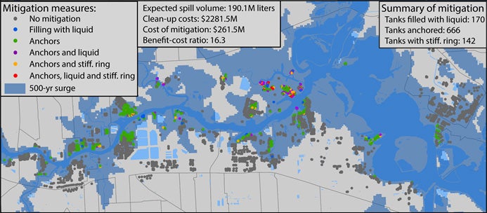
E) Optimal selection of mitigation strategies based on structural and social vulnerability
Description: Many studies looking at the optimal selection or prioritization of mitigation strategies for critical infrastructures mainly focus on reducing structural vulnerability and potential damage. However, considering social vulnerability is also important to target mitigation measures more efficiently in disadvantaged communities where they could have a greater impact; communities are not equally vulnerable to natural disasters as they have different capacities to prepare, respond, and recover from such events. Our work has developed an integrated model coupling natural hazard modeling, structural vulnerability modeling, and social vulnerability modeling to evaluate and quantify the effects and viability of mitigation strategies. As shown below, this framework was used to mitigate the risks posed by aboveground storage tanks (ASTs) in coastal regions. Based on this integrated framework, optimization-based and a heuristic-based methods were also developed to optimally select mitigation strategies in large-scale coastal industrial areas by considering structural vulnerability, social vulnerability, and economic viability. An example of optimal selection of mitigation measures for ASTs is shown on the map below.
Figures: